


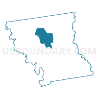
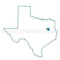
Voting District 0022, Anderson County, Texas
About
Outline

Summary
| Unique Area Identifier | 670081 |
| Name | Voting District 0022 |
| County | Anderson County |
| State | Texas |
| Area (square miles) | 59.10 |
| Land Area (square miles) | 58.58 |
| Water Area (square miles) | 0.51 |
| % of Land Area | 99.13 |
| % of Water Area | 0.87 |
| Latitude of the Internal Point | 31.88420350 |
| Longtitude of the Internal Point | -95.70313040 |
Maps

Graphs
Select a template below for downloading or customizing gragh for Voting District 0022, Anderson County, Texas


Neighbors
Neighoring Voting District (by Name) Neighboring Voting District on the Map
- Voting District 0011, Anderson County, TX
- Voting District 0017, Anderson County, TX
- Voting District 0021, Anderson County, TX
- Voting District 0023, Anderson County, TX
- Voting District 0024, Anderson County, TX
Top 10 Neighboring County Subdivision (by Population) Neighboring County Subdivision on the Map
- Palestine CCD, Anderson County, TX (29,440)
- Montalba-Tennessee Colony CCD, Anderson County, TX (16,445)
- Frankston CCD, Anderson County, TX (4,685)
Top 10 Neighboring Unified School District (by Population) Neighboring Unified School District on the Map
Top 10 Neighboring State Legislative District Lower Chamber (by Population) Neighboring State Legislative District Lower Chamber on the Map
Top 10 Neighboring State Legislative District Upper Chamber (by Population) Neighboring State Legislative District Upper Chamber on the Map
Top 10 Neighboring 111th Congressional District (by Population) Neighboring 111th Congressional District on the Map
Top 10 Neighboring Census Tract (by Population) Neighboring Census Tract on the Map
- Census Tract 9509.01, Anderson County, TX (5,938)
- Census Tract 9509.02, Anderson County, TX (4,834)
- Census Tract 9501, Anderson County, TX (4,685)
- Census Tract 9511, Anderson County, TX (4,388)
- Census Tract 9505, Anderson County, TX (4,377)